History of Project Updates
Update Notes
v2.5.2 Bugfix Upgrade
13 Sep 2021
minor
web/backend
- Several minor issues related to the v2.5 upgrade were found and fixed. The most significant issue was that product generation in the site was lagging behind the current cycle by 6 hours. Also, the link to the Houston radar was incorrect. The version number has been updated to v2.5.2.
- The real-time compilation of Vortex Data Messages (VDMs) is not yet working in TCGP v2.5. Development to fix this is on hold until there is a storm within range of reconnaissance, but which is still far from land.
- Unrelated to the v2.5 upgrade, a change made by the Joint Typhoon Warning Center (JTWC) broke TCGP's mirroring of the JTWC TCVITALS. This has been fixed.
Major v2.5 Upgrade
20 Aug 2021
major
all elements
- TCGP has undergone its most significant upgrade since 2011. The new TCGP v2.5 has a drastically improved code infrastructure, is now able to be run in the cloud, adds important new data sources such as TCVITALS and CARQ data obtained directly from the Joint Typhoon Warning Center (JTWC), and adds new graphical products such as wind exceedance plots from a new probabilistic framework. To learn more about all of these changes, please visit the TCGP v2.5 release notes.
Upgraded TCGP to handle Potential Tropical Cyclone nomenclature
10 Jul 2019
minor
web/back-end
- TCGP has been updated to handle the nomenclature for Potential Tropical Cyclones in the basins handled by the National Hurricane Center (NHC). When a developing disturbance is expected to develop and bring impacts to land within typical watch and warning timeframes, but it does not yet meet the criteria of a tropical depression, NHC now issues advisories for such systems as 'Potential Tropical Cyclones'. These systems are given a stormnumber, but are still designated as a Disturbance or Low. TCGP will now provide the proper terminology for such systems.
Example of a plot using the Potential Tropical Cyclone nomenclature. Click for full image.
Upgraded back-end scripts to NCL 6.4.0 and other enhancements
9 Oct 2017
minor
back-end
- TCGP's numerous back-end data handling and plotting scripts have been upgraded to use the latest version of NCAR Command Language (NCL v6.4.0). This change will provide TCGP will the full capabilities of the latest version of NCL. During the upgrade process, a few data issues occurred, such as the CHIPS ensemble not making it into the a-decks. For a 24-hour period, the b-decks for the Western Pacific basin were incorrectly truncated to one line, and the a-decks for this basin did not have the CARQ lines inserted. All of these issues have now been fixed.
- Additionally, two other enhancements were made to TCGP's back-end scripts. In the other global basins (e.g., Western Pacific, North Indian, Southern Hemisphere), the ATCF "cyclone type" field is typically not present. TCGP's routine that generates "nice" strings would normally put "CYCLONE TYPE UNKNOWN" in front of the storm name. This behavior has been changed so now nothing extra will be inserted before the storm name
- Also, this code has been updated to fix another issue. Because the ATCF field for stormname is truncated at 9 characters, when the stormname is a number (as is the case for tropical depressions), the truncated storm name (e.g., "TWENTY-TH") appeared in all of TCGP's links, page titles, and plots. Now, TCGP will use the full spelled-out number (e.g., "TWENTY-THREE").
Update to a higher resolution map database
21 Aug 2012
minor
graphics
- The TCGP plotting system has been updated to use a newer, higher resolution map database. For those who like details, maps now use the "Earth..4" map database in NCAR Command Language (NCL). The previous map database ("Earth..1") did not include the island of Barbados, as well as some of the U.S. and British Virgin Islands, the Cayman Islands, and many other small islands. The new map database will also allow the state boundaries of Mexico, Brazil, Canada, and several other countries to be included. The outlines of U.S. counties will now be displayed whenever the range of the map domain is smaller than 30 degrees.

Example of the old map database. The island of Barbados does not appear. Click for full image.
Example of a plot using the new map database. The coastline has much more detail and the map now displays the islands of Barbados, more of the British and U.S. Virgin Islands, the Cayman Islands, and many other smaller islands. Click for full image.
New server for TCGP
20 Sep 2011
major
web/backend
- The TCGP moves to a new server today. We expect the transition to be seamless to the users if they are using the http://www.ral.ucar.edu/hurricanes/ entry point. If you were previously using http://verif.rap.ucar.edu/guidance/ then please update your links. If you are still having trouble, please let us know.
Phase I released
14 Aug 2011
major
web/backend
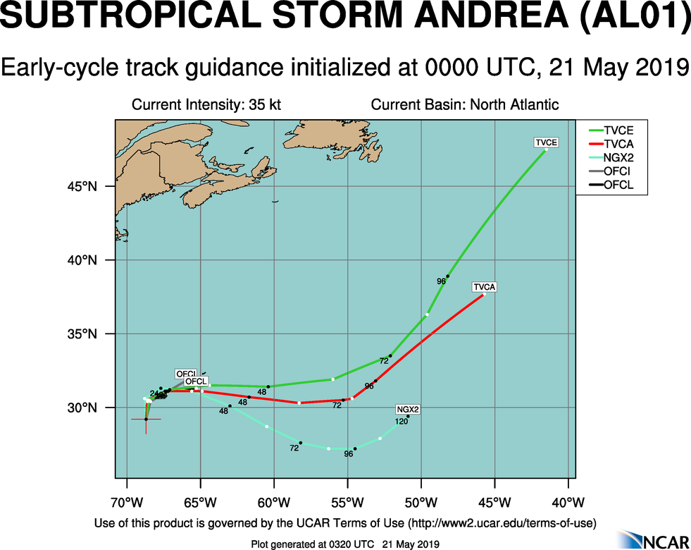
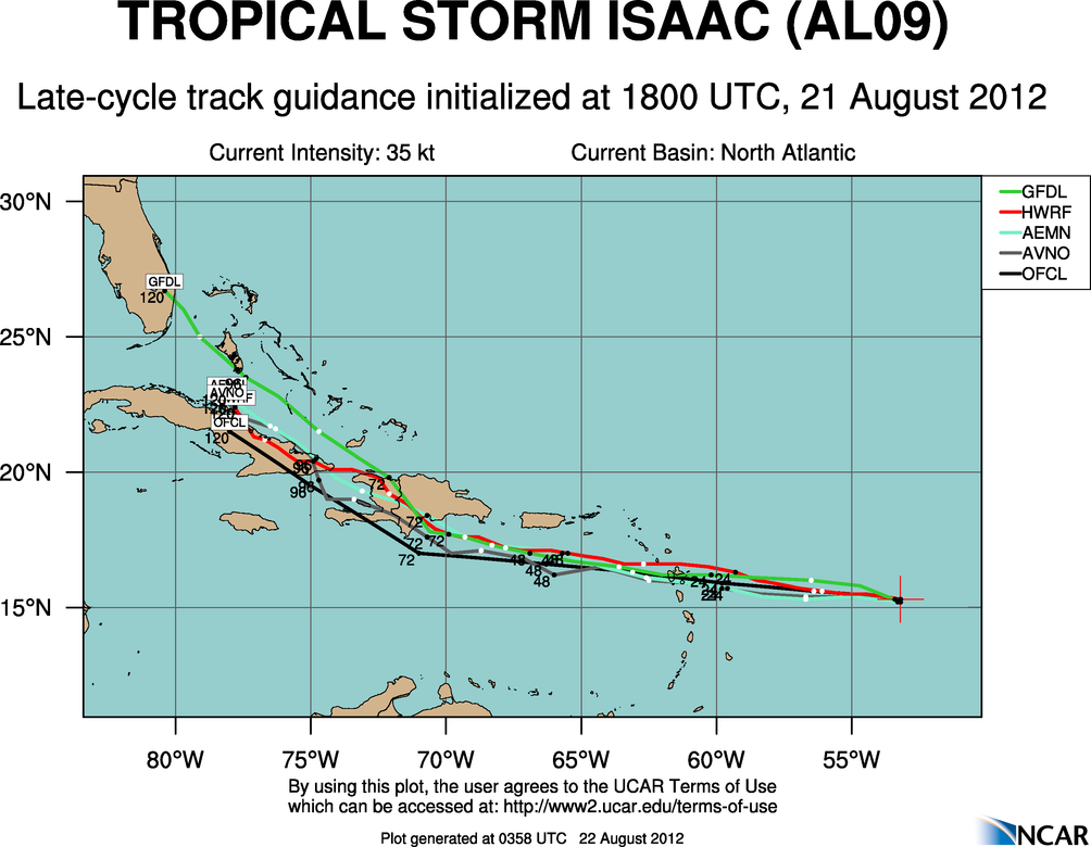
- Phase I of the Tropical Cyclone Guidance Project (TCGP) was released today. In this initial release, the repository includes all available track and intensity forecasts in the National Hurricane Center's public ATCF a-decks as well as the developmental tracker results from the UK Met Office global model. This release also features four types of real-time guidance plots for the North Atlantic, Northeast Pacific, and Central Pacific basins. These plot types are early cycle track guidance - late cycle track guidance - GFS ensemble track guidance - and early cycle intensity guidance.
- Phase I also implements a global overview map of current tropical cyclone activity with links to individual storm pages. Various text data files are also linked from each storm's individual storm pages.